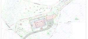
What is a Topographic Survey?
The purpose of a Topographic survey is to produce an accurate drawing of a particular piece of land which identifies and maps the contours of the ground and existing features on the site. It should include all natural and man-made features which will be indicated on a drawing by text, lines, and symbols. The drawing will also include heights and contours of the land, boundaries, tree positions and site structures.
What is a Topographic Survey used for?
Topographic surveys are used for a range of purposes, including:
- Supporting data for proposed developments
- Informing architects, engineers & clients prior to development design
- Supporting Land Registry submissions?
- Urban Regeneration projects
Our topographic surveys are carried out using a variety of equipment including precision GPS and Total Station equipment; survey information is then processed through dedicated software to produce the required outputs.
A Topographic survey will generally include any overhead services within the site as standard. However, particularly in urban centers, underground features can be just as important as the above ground features to a number of our clients.
Using traditional surveying techniques and manhole lifting equipment, we can ascertain the types and depths of most underground services. The typical data we would determine for clients would be inverted levels all types of service manholes together with information on pipes located within these manholes. This helps our clients, particularly engineers, in the design process of the drainage and services for a development.
Contact us on 051 393694 to discuss your topographic and utility survey needs.
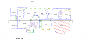
What is a Measured Building Survey?
A measured building survey is an accurate plan of the building clearly showing the structure, internal and external features and services. The detail required depends on the client’s requirements and the type of project it will be used for.
 What is a Measured Building Survey used for?
Measured building surveys are used for a variety of purposes, including:
- Supporting the decision making process of clients, architects, engineers and developers when planning and designing refurbishments and extensions
- Ensuring that Conservation architects/consultants have the relevant information when dealing with historical buildings
- Supporting estate agents when calculating areas for lease plans and sale brochures
Measured building surveys are carried out using a mixture of traditional surveying methods and a reflectorless Total Station. We are able to produce accurate and highly detailed drawings using this method. A typical measured building survey consists of floor and roof plans, external elevations and sections through the building. It can also include ceiling plans, internal elevations and streetscape elevations.
Contact us on 051 393694 to discuss your measured building survey needs.
Conservation survey
When it comes to surveying a historical building, we work very closely with the Conservation Architect/Consultant to ensure that the details they require are surveyed with maximum precision. Very often, the details in a historic or listed building will need to be reproduced and so we take great care in ensuring that the survey we produce will be as accurate as possible.
Historical detail surveys are generally used in the following circumstances:
- To provide accurate information to conservation architects when refurbishing older buildings
- To provide a record of details for historical records
- To provide a record of structural and/or element defects when planning for remedial works
Contact us on 051 393694 to discuss your Conservation survey needs.
Land surveying related to boundary and land registry mapping can be a complex and intricate process. We have a wealth of experience to provide a wide range of services related to legal mapping, boundary investigations and disputes, property subdivision and land registration.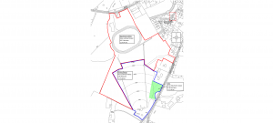
These services usually require us to interpret existing title deed maps and to survey existing boundaries on site which can then be superimposed onto legal Land Registry maps. This can help resolve disputes regarding boundary definition between neighbours or allows land to be transferred between parties.
We work closely with our clients and their solicitors to determine the mapping suitable for Land Registry submission, and offer reports and opinions on legal mapping issues.
Contact us on 051 393694 to discuss any aspect of boundary mapping or land registry maps.
Setting out is the process of transferring coordinates of a building, road or structure from design drawings to the ground/site. These set out points are typically indicated on the ground with the use of pegs/stakes, depending on the client’s requirements.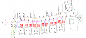
Cardinal Surveyors can use either Total Station or GPS equipment for setting out, depending on the site conditions. The features and structures typically set out would include:
- Site control
- Foundations
- Pile positions
- Building locations
- Drainage set out
- Alignment of roads, car-parks, kerbs
- Positions of existing utilities
Contact us on 051 393694 to discuss your Engineering or set-out survey needs.
An As-Built survey can provide a set of drawings of all relevant information of a development, be it a factory, school, hospital or housing estate. Very often, an as-built set of drawings will differ from the design drawings for a number of reasons, such as unexpected difficulties in construction requiring a design change. 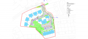
The purpose of an as-built survey is to establish accurately the position of all buildings, boundaries, and services. Local Authorities will require an as-built survey and set of drawings before they take a housing estate in charge and so we can carry out an as-built survey for the contractor at the end of the building phase.
As every building and client have a different set of needs for as built drawings, we work closely with the individual to ensure that their required information is collected and produced into a drawing accurately.
We use a mixture of traditional surveying techniques and the latest technology to produce accurate and highly detailed floor plans, elevations and sections of existing buildings.
Contact us on 051 393694 to discuss your As-built surveying needs.
The purpose of a volumetric survey is to determine the volume of material stockpiles, the amount of material removed from excavations and quarries and the amount of space left in landfills. 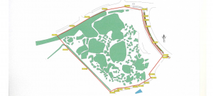
Cardinal Surveyors can carry out a volumetric survey in a range of situations, producing a drawing and report which will give an analysis of the volumes surveyed. This information can be very helpful to contractors, engineers, and clients to ensure that correct quantities are measured economically.
Volumetric surveys are often used to calculate the quantity of material to be excavated off a site or imported into the site and are also used when determining calculations for soil infill recovery sites.
Contact us on 051 393694 to discuss your Volumetric survey needs.
The auto track is a vehicle swept path analysis which calculates and analyses the movement and path of different parts of a vehicle when that vehicle is undertaking a turning manoeuvre. 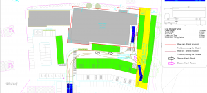
This includes calculating the path taken by each wheel during the turn and also calculating the space needed by the vehicle body during the turn.
This service is often used by engineers and designers to ensure that sufficient space is allocated to vehicles in small & large developments.
Contact us on 051 393694 to discuss your Autotrack survey needs.